 vesseltracker.com
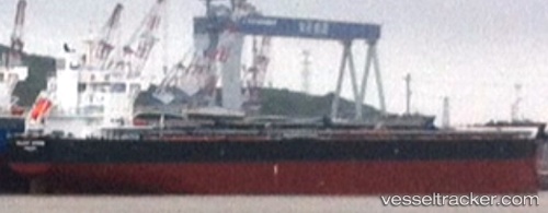
 VELA
VELA
Current Status
Where is the vessel?
VELA is currently in 273 nm SW of Santo Tomas, based on AIS data received less than 1h ago.
Latest AIS update:
Current position: 28.98167° N, 121.04833° W (273 nm SW of Santo Tomas)
Average speed (last 7 days): Loading…
Average speed (last 30 days): Loading…
Vessel profile: VELA is a Cargo with dimensions m x m.
This page combines live AIS, route history, probable destination signals, nearby traffic, and port activity for practical vessel monitoring.
The current position of vessel VELA is 28.98167 lat / -121.04833 lng. Updated: 2026-04-16 21:51:24 UTCNearest reference points:
- Open sea, approx. 408 nm off the nearest listed port
- Open sea, approx. 407 nm off the nearest listed port
- Open sea, approx. 421 nm off the nearest listed port
Currently sailing under the flag of Marshall Islands ![]()
Details:
Live Vessel VELA Analytics (details, animations, etc.)
Recent AIS points (UTC):
2026-04-16 13:27:49 UTC · 30.43222, -122.28755 · SOG 13 kn · COG 138°2026-04-16 16:23:54 UTC · 29.94243, -121.81931 · SOG 13.2 kn · COG 142°
2026-04-16 20:09:21 UTC · 29.27950, -121.28044 · SOG 12.7 kn · COG 142°
2026-04-16 21:51:24 UTC · 28.98167, -121.04833 · SOG 12 kn · COG -1°