 vesseltracker.com
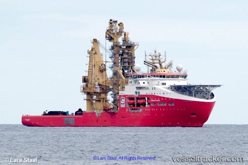
 Normand Maximus
Current Status
Where is the vessel?
Normand Maximus is currently in Near Pinto Island, based on AIS data received about 1h ago.
Latest AIS update:
Current position: 30.52543° N, 88.08735° W (Near Pinto Island)
Average speed (last 7 days): Loading…
Average speed (last 30 days): Loading…
Vessel profile: Normand Maximus is a Offshore Support Vessel with dimensions 178m x 180m.
This page combines live AIS, route history, probable destination signals, nearby traffic, and port activity for practical vessel monitoring.
The current position of vessel Normand Maximus is 30.52543 lat / -88.08735 lng. Updated: 2026-03-26 15:27:22 UTCNearest reference points:
- Near Point Clear
- Near Pinto Island
- Near Mobile
Currently sailing under the flag of Norway ![]()
Details:
Live Vessel Normand Maximus Analytics (details, animations, etc.)
Recent AIS points (UTC):
2026-03-26 09:56:29 UTC · 30.52541, -88.08736 · SOG 0 kn · COG 156°2026-03-26 12:23:30 UTC · 30.52542, -88.08734 · SOG 0 kn · COG 156°
2026-03-26 13:35:32 UTC · 30.52541, -88.08735 · SOG 0 kn · COG 156°
2026-03-26 15:27:22 UTC · 30.52543, -88.08735 · SOG 0 kn · COG 156°