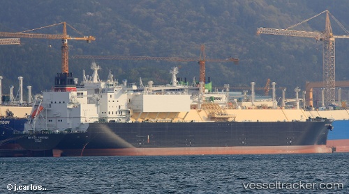
.
Vessel photo of British Partner (IMO 9766530) vesseltracker.com

GB flag British Partner

Vessel type: Lng Tanker | IMO: 9766530 | MMSI: MMSI: 232006301
Call sign: MAOS2 | Dimensions: 295 m x 46 m
Current Status

Where is the vessel?

British Partner is currently in 114 nm N of Mapia Island, based on AIS data received about 2h ago.

Latest AIS update:

Current position: 2.72007° N, 133.82069° E (114 nm N of Mapia Island)

Average speed (last 7 days): Loading…

Average speed (last 30 days): Loading…

Vessel profile: British Partner is a Lng Tanker with dimensions 295m x 46m.

This page combines live AIS, route history, probable destination signals, nearby traffic, and port activity for practical vessel monitoring.

The current position of vessel British Partner is 2.72007 lat / 133.82069 lng. Updated: 2026-03-31 13:25:38 UTC

Currently sailing under the flag of United Kingdom GB flag

Details:

Live Vessel British Partner Analytics (details, animations, etc.)


Recent AIS points (UTC):
2026-03-31 07:57:39 UTC · 2.86526, 133.85085 · SOG 2 kn · COG 99°
2026-03-31 09:52:50 UTC · 2.80502, 133.83987 · SOG 1.8 kn · COG 93°
2026-03-31 11:25:38 UTC · 2.76367, 133.82909 · SOG 1.5 kn · COG 95°
2026-03-31 13:25:38 UTC · 2.72007, 133.82069 · SOG 1.1 kn · COG 86°

Track of the vessel in the last 60 days


UTC: --
Start: -- Track timeline (UTC) End: --
Encountered: --


Link to the map:


Find another ship

British_Partner (232006301) last ports (portcalls and passsages)

Quintana | 2025-09-05 23:54:18
POINT FORTIN | 2025-07-28 11:57:01
POINT FORTIN | 2025-07-07 11:17:11
CAMERON | 2025-05-24 10:48:21
POINT FORTIN | 2025-04-04 12:39:45
JURONG ISLAND | 2025-03-06 00:25:23
BUKOM ISLAND | 2025-03-04 22:02:19
TANAH MERAH | 2025-03-04 20:42:05
PENGERANG | 2025-03-04 18:59:14
PYEONGTAEK | 2025-02-24 04:26:50
DAESAN | 2025-02-24 02:06:02
TAEAN-GUN | 2025-02-24 01:20:01
TANAH MERAH | 2025-02-15 05:53:09
PULAU SAMBU | 2025-02-15 04:42:46
BUKOM ISLAND | 2025-02-12 02:13:48
JURONG ISLAND | 2025-01-10 08:17:54
BUKOM ISLAND | 2025-01-10 06:42:33
JURONG ISLAND | 2025-01-06 06:48:34
BUKOM ISLAND | 2025-01-06 06:24:39
PULAU SAMBU | 2025-01-06 04:26:44
PENGERANG | 2025-01-06 02:39:44
Map Ta Phut | 2025-01-02 23:08:35
PENGERANG | 2024-12-31 04:36:40
TANAH MERAH | 2024-12-31 04:08:12
PULAU SAMBU | 2024-12-31 03:42:28
Victoria | 2024-12-09 06:20:10
BUKOM ISLAND | 2024-11-26 11:43:50
JURONG ISLAND | 2024-11-26 09:45:25
BUKOM ISLAND | 2024-11-22 11:31:53
BUKOM ISLAND | 2024-11-18 11:15:49
BUKOM ISLAND | 2024-11-14 11:06:58
PULAU SAMBU | 2024-11-14 10:32:07
Selat Lombok | 2024-10-20 23:52:55
Sambu | 2024-10-18 10:19:42
Singapore | 2024-06-28 01:14:31
Singapore | 2024-06-23 07:06:46
Sambu | 2024-06-22 01:30:39
Singapore | 2024-06-03 00:44:26
Singapore | 2024-05-17 09:24:28
Singapore | 2024-04-13 07:30:15
Osaka | 2024-04-04 23:52:42
Sambu | 2024-03-29 07:25:14
Singapore | 2024-03-02 01:26:45
Singapore | 2024-02-03 00:00:13
Map Ta Phut | 2023-08-20 22:44:00
Sambu | 2023-08-18 09:16:05
Victoria | 2023-07-14 04:59:17
Singapore | 2023-06-13 10:04:23
Singapore | 2023-02-11 02:05:35
Sambu | 2023-02-09 02:02:58
Singapore | 2022-12-09 05:26:02
Cochin | 2022-10-06 07:40:43
Mutrah | 2022-09-30 07:18:51
Singapore | 2022-09-18 04:43:32
Mutrah | 2022-07-15 07:03:58
Wakamatsu | 2022-06-14 07:28:59
Barrow Island | 2022-05-20 08:06:07
Strait Of Gibraltar | 2022-01-05 15:30:56
Cartagena | 2022-01-03 06:34:28
Strait Of Gibraltar | 2022-01-02 08:36:53
Puerto De La Luz | 2021-12-30 17:45:13