 vesseltracker.com
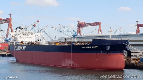
 Cap Corpus Christi
Current Status
Where is the vessel?
Cap Corpus Christi is currently in 10 nm N of Sainte-Anne-des-Monts, based on AIS data received about 1h ago.
Latest AIS update:
Current position: 49.28433° N, 66.49690° W (10 nm N of Sainte-Anne-des-Monts)
Average speed (last 7 days): Loading…
Average speed (last 30 days): Loading…
Vessel profile: Cap Corpus Christi is a Crude Oil Tanker with dimensions 277m x 48m.
This page combines live AIS, route history, probable destination signals, nearby traffic, and port activity for practical vessel monitoring.
The current position of vessel Cap Corpus Christi is 49.28433 lat / -66.49690 lng. Updated: 2026-04-16 14:03:59 UTCNearest reference points:
- 22 nm N of Sainte-Anne-des-Monts
- 15 nm NW of Saint-Anaclet
Currently sailing under the flag of Greece ![]()
Details:
Live Vessel Cap Corpus Christi Analytics (details, animations, etc.)
Recent AIS points (UTC):
2026-04-16 07:21:39 UTC · 48.91745, -67.90216 · SOG 8.6 kn · COG 57°2026-04-16 10:19:38 UTC · 49.10186, -67.31715 · SOG 8.9 kn · COG 63°
2026-04-16 11:34:00 UTC · 49.16739, -67.06403 · SOG 9 kn · COG 73°
2026-04-16 14:03:59 UTC · 49.28433, -66.49690 · SOG 9.3 kn · COG 71°