 vesseltracker.com
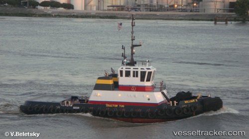
 William S
Current Status
Where is the vessel?
William S is currently in Near Leblanc, based on AIS data received about 1h ago.
Latest AIS update:
Current position: 30.27271° N, 91.14200° W (Near Leblanc)
Average speed (last 7 days): Loading…
Average speed (last 30 days): Loading…
Vessel profile: William S is a Tug with dimensions 30m x 11m.
This page combines live AIS, route history, probable destination signals, nearby traffic, and port activity for practical vessel monitoring.
The current position of vessel William S is 30.27271 lat / -91.14200 lng. Updated: 2026-04-19 23:53:21 UTCNearest reference points:
- Near Brusly
- Near Baton Rouge
- Near Port Of South Louisiana
Currently sailing under the flag of USA ![]()
Details:
Live Vessel William S Analytics (details, animations, etc.)
Recent AIS points (UTC):
2026-04-19 19:47:59 UTC · 30.27271, -91.14200 · SOG 0 kn · COG 277°2026-04-19 21:27:20 UTC · 30.27269, -91.14199 · SOG 0 kn · COG 277°
2026-04-19 22:26:20 UTC · 30.27270, -91.14199 · SOG 0 kn · COG 277°
2026-04-19 23:53:21 UTC · 30.27271, -91.14200 · SOG 0 kn · COG 278°