 vesseltracker.com
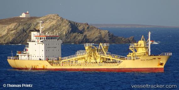
 THANOS
Current Status
Where is the vessel?
THANOS is currently in Near Rhodes, based on AIS data received less than 1h ago.
Latest AIS update:
Current position: 36.44260° N, 28.23657° E (Near Rhodes)
Average speed (last 7 days): Loading…
Average speed (last 30 days): Loading…
Vessel profile: THANOS is a Cement Carrier with dimensions 78m x 13m.
This page combines live AIS, route history, probable destination signals, nearby traffic, and port activity for practical vessel monitoring.
The current position of vessel THANOS is 36.44260 lat / 28.23657 lng. Updated: 2026-03-29 22:19:33 UTCNearest reference points:
- Near Rhodes
- Near Kremasti
- Near Içmeler
Currently sailing under the flag of Cyprus ![]()
THANOS built in 1992 year
Deadweight:
2218 tDetails:
Live Vessel THANOS Analytics (details, animations, etc.)
Recent AIS points (UTC):
2026-03-29 15:43:32 UTC · 36.44259, 28.23659 · SOG 0 kn · COG 74°2026-03-29 17:41:09 UTC · 36.44263, 28.23656 · SOG 0 kn · COG -1°
2026-03-29 19:43:34 UTC · 36.44261, 28.23657 · SOG 0 kn · COG 303°
2026-03-29 22:19:33 UTC · 36.44260, 28.23657 · SOG 0 kn · COG 219°