 vesseltracker.com
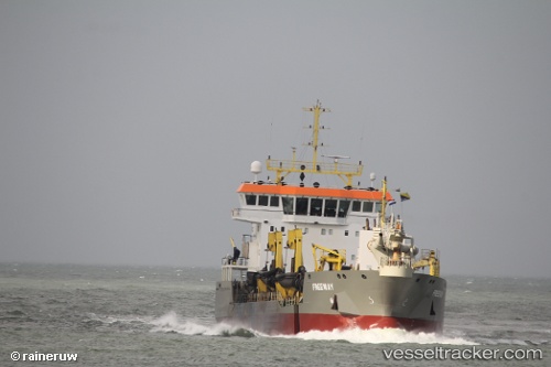
 Freeway
Current Status
Where is the vessel?
Freeway is currently in Near HOEK VAN HOLLAND, based on AIS data received about 1h ago.
Latest AIS update:
Current position: 51.97829° N, 4.10449° E (Near HOEK VAN HOLLAND)
Average speed (last 7 days): Loading…
Average speed (last 30 days): Loading…
Vessel profile: Freeway is a Hopper Dredger with dimensions 92m x 92m.
This page combines live AIS, route history, probable destination signals, nearby traffic, and port activity for practical vessel monitoring.
The current position of vessel Freeway is 51.97829 lat / 4.10449 lng. Updated: 2026-04-06 05:27:28 UTCNearest reference points:
- Near HOEK VAN HOLLAND
- Near MAASVLAKTE - ROTTERDAM
- Near BRIELLE
Currently sailing under the flag of Cyprus ![]()
Details:
Live Vessel Freeway Analytics (details, animations, etc.)
Recent AIS points (UTC):
2026-04-05 23:54:48 UTC · 51.99592, 3.99461 · SOG 7.1 kn · COG 90°2026-04-06 01:48:08 UTC · 51.90239, 4.28143 · SOG 0.1 kn · COG 119°
2026-04-06 03:56:19 UTC · 51.99223, 3.92010 · SOG 1.6 kn · COG 227°
2026-04-06 05:27:28 UTC · 51.97829, 4.10449 · SOG 9.7 kn · COG 111°