 vesseltracker.com
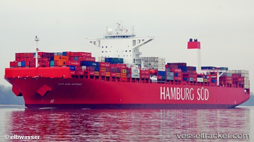
 Cap San Antonio
Current Status
Where is the vessel?
Cap San Antonio is currently in Near Atucha, based on AIS data received less than 1h ago.
Latest AIS update:
Current position: 34.58051° S, 58.36727° W (Near Atucha)
Average speed (last 7 days): Loading…
Average speed (last 30 days): Loading…
Vessel profile: Cap San Antonio is a Container Ship with dimensions 333m x 333m.
This page combines live AIS, route history, probable destination signals, nearby traffic, and port activity for practical vessel monitoring.
The current position of vessel Cap San Antonio is -34.58051 lat / -58.36727 lng. Updated: 2026-04-12 10:04:09 UTCNearest reference points:
- Near Avellaneda
- Near Dock Sur
- Near JUAN LACAZE
Currently sailing under the flag of Denmark ![]()
Cap San Antonio built in 2014 year
Deadweight:
124424 tDetails:
Live Vessel Cap San Antonio Analytics (details, animations, etc.)
Recent AIS points (UTC):
2026-04-10 07:49:56 UTC · -29.33793, -48.98190 · SOG 18.9 kn · COG 211°2026-04-12 07:30:23 UTC · -34.58052, -58.36727 · SOG 0 kn · COG 84°
2026-04-12 07:54:20 UTC · -34.58050, -58.36727 · SOG 0 kn · COG 85°
2026-04-12 10:04:09 UTC · -34.58051, -58.36727 · SOG 0 kn · COG 84°