 vesseltracker.com
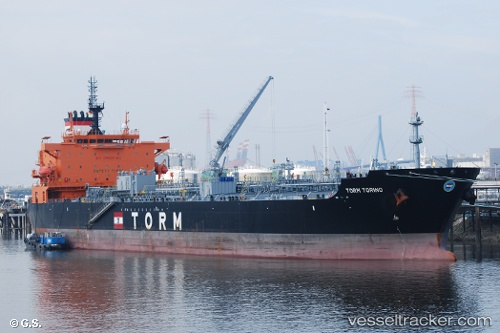
 TORM TORINO
Current Status
Where is the vessel?
TORM TORINO is currently in Near PENGERANG, based on AIS data received less than 1h ago.
Latest AIS update:
Current position: 1.31190° N, 104.14651° E (Near PENGERANG)
Average speed (last 7 days): Loading…
Average speed (last 30 days): Loading…
Vessel profile: TORM TORINO is a Chemical/Oil Products Tanker with dimensions 183m x 32m.
This page combines live AIS, route history, probable destination signals, nearby traffic, and port activity for practical vessel monitoring.
The current position of vessel TORM TORINO is 1.31190 lat / 104.14651 lng. Updated: 2026-04-08 17:26:58 UTCNearest reference points:
- Near PENGERANG
- Near TANAH MERAH
- Near Tanjung Setapa
Currently sailing under the flag of Denmark (DIS) ![]()
TORM TORINO built in 2016 year
Deadweight:
49667 tDetails:
Live Vessel TORM TORINO Analytics (details, animations, etc.)
Recent AIS points (UTC):
2026-04-08 11:28:33 UTC · 1.29909, 104.16331 · SOG 7.6 kn · COG 259°2026-04-08 13:29:59 UTC · 1.31210, 104.14644 · SOG 0 kn · COG 78°
2026-04-08 15:29:58 UTC · 1.31216, 104.14634 · SOG 0 kn · COG 86°
2026-04-08 17:26:58 UTC · 1.31190, 104.14651 · SOG 0 kn · COG 75°