 vesseltracker.com
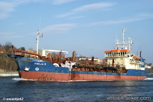
 Freja R
Current Status
Where is the vessel?
Freja R is currently in Near HVIDE SANDE, based on AIS data received less than 1h ago.
Latest AIS update:
Current position: 56.00176° N, 8.12015° E (Near HVIDE SANDE)
Average speed (last 7 days): Loading…
Average speed (last 30 days): Loading…
Vessel profile: Freja R is a Hopper Dredger with dimensions 77m x 14m.
This page combines live AIS, route history, probable destination signals, nearby traffic, and port activity for practical vessel monitoring.
The current position of vessel Freja R is 56.00176 lat / 8.12015 lng. Updated: 2026-04-21 22:10:01 UTCNearest reference points:
- Near Blavand
- Near Fanoe
- Near Esbjerg
Currently sailing under the flag of Denmark ![]()
Freja R built in 1982 year
Deadweight:
2784 tDetails:
Live Vessel Freja R Analytics (details, animations, etc.)
Recent AIS points (UTC):
2026-04-21 19:52:10 UTC · 56.00183, 8.11900 · SOG 0 kn · COG 107°2026-04-21 20:26:00 UTC · 56.00190, 8.11943 · SOG 0 kn · COG 101°
2026-04-21 21:35:40 UTC · 56.00172, 8.12057 · SOG 0.1 kn · COG 96°
2026-04-21 22:10:01 UTC · 56.00176, 8.12015 · SOG 0.4 kn · COG 99°