 vesseltracker.com
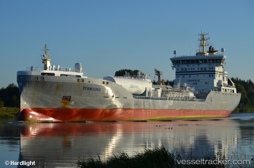
 Ternsund
Current Status
Where is the vessel?
Ternsund is currently in 12 nm NW of Llanwrda, based on AIS data received about 1d ago.
Latest AIS update:
Current position: 52.14775° N, 3.71012° E (12 nm NW of Llanwrda)
Average speed (last 7 days): Loading…
Average speed (last 30 days): Loading…
Vessel profile: Ternsund is a Chemical Oil Products Tanker with dimensions 147m x 22m.
This page combines live AIS, route history, probable destination signals, nearby traffic, and port activity for practical vessel monitoring.
The current position of vessel Ternsund is 52.14775 lat / 3.71012 lng. Updated: 2026-04-10 07:25:45 UTCNearest reference points:
- Near Haarlemmermeer
- 12 nm NE of Hunsdon
- Near MAASVLAKTE - ROTTERDAM
Currently sailing under the flag of Denmark ![]()
Details:
Live Vessel Ternsund Analytics (details, animations, etc.)
Recent AIS points (UTC):
2026-04-10 02:23:59 UTC · 52.61801, 3.22849 · SOG 11.1 kn · COG 185°2026-04-10 03:49:10 UTC · 52.35317, 3.20595 · SOG 11 kn · COG 179°
2026-04-10 05:57:59 UTC · 52.15038, 3.67024 · SOG 11.5 kn · COG 107°
2026-04-10 07:25:45 UTC · 52.14775, 3.71012 · SOG 0.1 kn · COG 288°