 vesseltracker.com
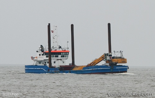
 Camilla Hoej
Current Status
Where is the vessel?
Camilla Hoej is currently in Near Horsens, based on AIS data received about 2h ago.
Latest AIS update:
Current position: 55.85748° N, 9.85957° E (Near Horsens)
Average speed (last 7 days): Loading…
Average speed (last 30 days): Loading…
Vessel profile: Camilla Hoej is a Dredger with dimensions 40m x 12m.
This page combines live AIS, route history, probable destination signals, nearby traffic, and port activity for practical vessel monitoring.
The current position of vessel Camilla Hoej is 55.85748 lat / 9.85957 lng. Updated: 2026-04-05 03:24:30 UTCNearest reference points:
- Near Horsens
- Near Kolding
- Near Randers
Currently sailing under the flag of Denmark ![]()
Camilla Hoej built in 1972 year
Deadweight:
610 tDetails:
Live Vessel Camilla Hoej Analytics (details, animations, etc.)
Recent AIS points (UTC):
2026-04-04 22:15:20 UTC · 55.85746, 9.85958 · SOG 0 kn · COG 156°2026-04-04 23:27:30 UTC · 55.85750, 9.85956 · SOG 0 kn · COG 156°
2026-04-05 01:07:49 UTC · 55.85747, 9.85957 · SOG 0 kn · COG 156°
2026-04-05 03:24:30 UTC · 55.85748, 9.85957 · SOG 0 kn · COG 155°