 vesseltracker.com
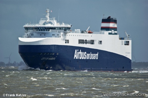
 City Of Hamburg
Current Status
Where is the vessel?
City Of Hamburg is currently in Near MONTOIR, based on AIS data received about 2h ago.
Latest AIS update:
Current position: 47.28986° N, 2.16692° W (Near MONTOIR)
Average speed (last 7 days): Loading…
Average speed (last 30 days): Loading…
Vessel profile: City Of Hamburg is a Ro Ro Cargo Ship with dimensions 125m x 26m.
This page combines live AIS, route history, probable destination signals, nearby traffic, and port activity for practical vessel monitoring.
The current position of vessel City Of Hamburg is 47.28986 lat / -2.16692 lng. Updated: 2026-03-26 11:47:52 UTCNearest reference points:
- Near Arzal
- Near Camoël
- Near LE CROISIC
Currently sailing under the flag of France ![]()
City Of Hamburg built in 2008 year
Deadweight:
3546 tDetails:
Live Vessel City Of Hamburg Analytics (details, animations, etc.)
Recent AIS points (UTC):
2026-03-26 05:38:55 UTC · 47.28986, -2.16692 · SOG 0 kn · COG 230°2026-03-26 08:02:56 UTC · 47.28986, -2.16691 · SOG 0 kn · COG 231°
2026-03-26 10:11:50 UTC · 47.28982, -2.16696 · SOG 0.1 kn · COG 231°
2026-03-26 11:47:52 UTC · 47.28986, -2.16692 · SOG 0 kn · COG 231°