 vesseltracker.com
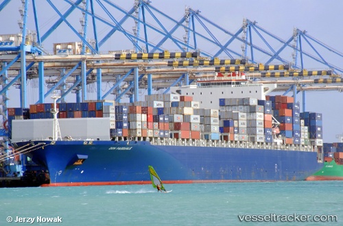
 CMA CGM DON PASCUALE
Current Status
Where is the vessel?
CMA CGM DON PASCUALE is currently in Near Kalafrana, based on AIS data received less than 1h ago.
Latest AIS update:
Current position: 35.82094° N, 14.53487° E (Near Kalafrana)
Average speed (last 7 days): Loading…
Average speed (last 30 days): Loading…
Vessel profile: CMA CGM DON PASCUALE is a Container Ship with dimensions 334m x 334m.
This page combines live AIS, route history, probable destination signals, nearby traffic, and port activity for practical vessel monitoring.
The current position of vessel CMA CGM DON PASCUALE is 35.82094 lat / 14.53487 lng. Updated: 2026-04-12 21:30:08 UTCNearest reference points:
- Near Floriana
- Near Birgu (Vittoriosa)
- Near Valletta
Currently sailing under the flag of Malta ![]()
CMA CGM DON PASCUALE built in 2007 year
Deadweight:
101477 tDetails:
Live Vessel CMA CGM DON PASCUALE Analytics (details, animations, etc.)
Recent AIS points (UTC):
2026-04-12 15:30:28 UTC · 35.79488, 14.68115 · SOG 2 kn · COG 233°2026-04-12 17:47:49 UTC · 35.82305, 14.54821 · SOG 6 kn · COG 292°
2026-04-12 19:50:53 UTC · 35.82093, 14.53487 · SOG 0 kn · COG 129°
2026-04-12 21:30:08 UTC · 35.82094, 14.53487 · SOG 0 kn · COG 128°