 vesseltracker.com
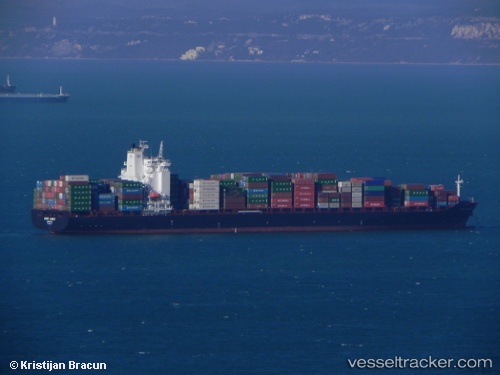
 FORT DESAIX
Current Status
Where is the vessel?
FORT DESAIX is currently in 42 nm SE of San Clodio, based on AIS data received less than 1h ago.
Latest AIS update:
Current position: 48.06206° N, 6.44363° W (42 nm SE of San Clodio)
Average speed (last 7 days): Loading…
Average speed (last 30 days): Loading…
Vessel profile: FORT DESAIX is a Container Ship with dimensions 32m x 269m.
This page combines live AIS, route history, probable destination signals, nearby traffic, and port activity for practical vessel monitoring.
The current position of vessel FORT DESAIX is 48.06206 lat / -6.44363 lng. Updated: 2026-04-09 09:55:25 UTCNearest reference points:
- 35 nm SW of Ile D’Ouessant
- 60 nm SE of San Clodio
- 46 nm W of SEIN
Currently sailing under the flag of Malta ![]()
FORT DESAIX built in 2010 year
Deadweight:
52788 tDetails:
Live Vessel FORT DESAIX Analytics (details, animations, etc.)
Recent AIS points (UTC):
2026-04-09 03:21:55 UTC · 49.22584, -4.87812 · SOG 15.7 kn · COG 221°2026-04-09 05:40:18 UTC · 48.95397, -5.63766 · SOG 14.7 kn · COG 234°
2026-04-09 07:28:01 UTC · 48.60687, -6.01036 · SOG 14.8 kn · COG 208°
2026-04-09 09:55:25 UTC · 48.06206, -6.44363 · SOG 15.5 kn · COG 214°