 vesseltracker.com
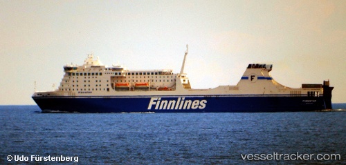
 Finnstar
Current Status
Where is the vessel?
Finnstar is currently in Near Travemunde, based on AIS data received less than 1h ago.
Latest AIS update:
Current position: 53.94311° N, 10.86149° E (Near Travemunde)
Average speed (last 7 days): Loading…
Average speed (last 30 days): Loading…
Vessel profile: Finnstar is a Passenger Ro Ro Cargo Ship with dimensions 219m x 32m.
This page combines live AIS, route history, probable destination signals, nearby traffic, and port activity for practical vessel monitoring.
The current position of vessel Finnstar is 53.94311 lat / 10.86149 lng. Updated: 2026-04-21 21:32:50 UTCNearest reference points:
- Near NIENDORFER
- Near NEUSTADT
- Near Sereetz
Currently sailing under the flag of Finland ![]()
Finnstar built in 2006 year
Deadweight:
9653 tDetails:
Live Vessel Finnstar Analytics (details, animations, etc.)
Recent AIS points (UTC):
2026-04-21 17:58:44 UTC · 54.03293, 11.00288 · SOG 19.3 kn · COG 226°2026-04-21 19:50:49 UTC · 53.94311, 10.86148 · SOG 0 kn · COG 18°
2026-04-21 20:24:43 UTC · 53.95173, 10.86090 · SOG 1.9 kn · COG 342°
2026-04-21 21:32:50 UTC · 53.94311, 10.86149 · SOG 0 kn · COG 18°