 vesseltracker.com
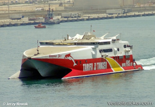
 TARIFA JET
Current Status
Where is the vessel?
TARIFA JET is currently in Near Castletown, based on AIS data received about 20h ago.
Latest AIS update:
Current position: 50.57202° N, 2.44062° W (Near Castletown)
Average speed (last 7 days): Loading…
Average speed (last 30 days): Loading…
Vessel profile: TARIFA JET is a High speed craft with dimensions m x m.
This page combines live AIS, route history, probable destination signals, nearby traffic, and port activity for practical vessel monitoring.
The current position of vessel TARIFA JET is 50.57202 lat / -2.44062 lng. Updated: 2026-04-10 08:06:35 UTCNearest reference points:
- Near Castletown
- Near WEYMOUTH
- Near Poole
Currently sailing under the flag of United Kingdom ![]()
Details:
Live Vessel TARIFA JET Analytics (details, animations, etc.)
Recent AIS points (UTC):
2026-04-10 02:36:36 UTC · 50.57203, -2.44061 · SOG 0 kn · COG 13°2026-04-10 04:18:34 UTC · 50.57203, -2.44061 · SOG 0 kn · COG 13°
2026-04-10 05:21:34 UTC · 50.57203, -2.44061 · SOG 0 kn · COG 13°
2026-04-10 08:06:35 UTC · 50.57202, -2.44062 · SOG 0 kn · COG 12°