 vesseltracker.com
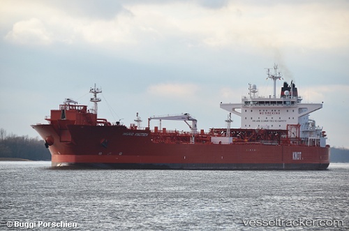
 Ingrid Knutsen
Current Status
Where is the vessel?
Ingrid Knutsen is currently in Near Martofte, based on AIS data received less than 1h ago.
Latest AIS update:
Current position: 55.68214° N, 10.71667° E (Near Martofte)
Average speed (last 7 days): Loading…
Average speed (last 30 days): Loading…
Vessel profile: Ingrid Knutsen is a Crude Oil Tanker with dimensions 257m x 43m.
This page combines live AIS, route history, probable destination signals, nearby traffic, and port activity for practical vessel monitoring.
The current position of vessel Ingrid Knutsen is 55.68214 lat / 10.71667 lng. Updated: 2026-04-07 10:19:54 UTCNearest reference points:
- Near Kalundborg
- Near Lindholm Havn
- Near Lundeborg
Currently sailing under the flag of United Kingdom ![]()
Ingrid Knutsen built in 2013 year
Deadweight:
111634 tDetails:
Live Vessel Ingrid Knutsen Analytics (details, animations, etc.)
Recent AIS points (UTC):
2026-04-07 04:16:46 UTC · 55.68201, 10.71666 · SOG 0 kn · COG 346°2026-04-07 06:16:50 UTC · 55.68205, 10.71686 · SOG 0 kn · COG 348°
2026-04-07 07:25:48 UTC · 55.68203, 10.71629 · SOG 0 kn · COG 0°
2026-04-07 10:19:54 UTC · 55.68214, 10.71667 · SOG 0 kn · COG 348°