 vesseltracker.com
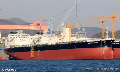
British Rigour
Current StatusWhere is the vessel?
British Rigour is currently in Near SCAPA, based on AIS data received about 1h ago.
Latest AIS update:
Current position: 58.91929° N, 3.01858° W (Near SCAPA)
Average speed (last 7 days): Loading…
Average speed (last 30 days): Loading…
Vessel profile: British Rigour is a Crude Oil Tanker with dimensions 44m x 250m.
This page combines live AIS, route history, probable destination signals, nearby traffic, and port activity for practical vessel monitoring.
The current position of vessel British Rigour is 58.91929 lat / -3.01858 lng. Updated: 2026-04-09 15:33:00 UTCNearest reference points:
- Near Tingwall
- Near STROMNESS
- Near Staxigoe
Details:
Live Vessel British Rigour Analytics (details, animations, etc.)
Recent AIS points (UTC):
2026-04-09 09:54:13 UTC · 58.92142, -3.01797 · SOG 0.1 kn · COG 257°2026-04-09 11:42:10 UTC · 58.92032, -3.01790 · SOG 0 kn · COG 283°
2026-04-09 13:48:14 UTC · 58.91980, -3.01775 · SOG 0 kn · COG 294°
2026-04-09 15:33:00 UTC · 58.91929, -3.01858 · SOG 0.1 kn · COG 309°