 vesseltracker.com
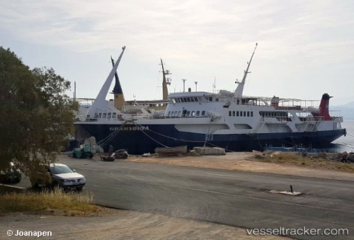
 Gramvousa
Current Status
Where is the vessel?
Gramvousa is currently in Near KISSAMOS, based on AIS data received about 1h ago.
Latest AIS update:
Current position: 35.51667° N, 23.63667° E (Near KISSAMOS)
Average speed (last 7 days): Loading…
Average speed (last 30 days): Loading…
Vessel profile: Gramvousa is a Passenger Ro Ro Cargo Ship with dimensions 78m x 15m.
This page combines live AIS, route history, probable destination signals, nearby traffic, and port activity for practical vessel monitoring.
The current position of vessel Gramvousa is 35.51667 lat / 23.63667 lng. Updated: 2026-04-20 19:51:33 UTCNearest reference points:
- Near Kythira
- 59 nm W of Paleochora
- 17 nm W of Milos (Adamas)
Currently sailing under the flag of Greece ![]()
Gramvousa built in 1981 year
Deadweight:
350 tDetails:
Live Vessel Gramvousa Analytics (details, animations, etc.)
Recent AIS points (UTC):
2026-04-20 16:37:22 UTC · 35.51713, 23.63723 · SOG 0 kn · COG -1°2026-04-20 17:22:26 UTC · 35.51713, 23.63723 · SOG 0 kn · COG -1°
2026-04-20 19:10:22 UTC · 35.51713, 23.63725 · SOG 0 kn · COG -1°
2026-04-20 19:51:33 UTC · 35.51667, 23.63667 · SOG 0 kn · COG -1°