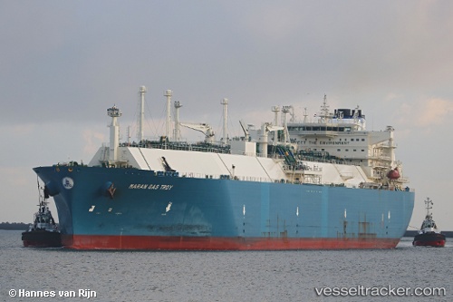
.
Vessel photo of Maran Gas Troy (IMO 9658240) vesseltracker.com

Maran Gas Troy

Vessel type: Lng Tanker | IMO: 9658240 | MMSI: MMSI: 241352000
Call sign: SVCB8 | Dimensions: 44 m x 294 m
Current Status

Where is the vessel?

Maran Gas Troy is currently in Near Tuas, based on AIS data received about 3h ago.

Latest AIS update:

Current position: 1.30031° N, 103.65073° E (Near Tuas)

Average speed (last 7 days): Loading…

Average speed (last 30 days): Loading…

Vessel profile: Maran Gas Troy is a Lng Tanker with dimensions 44m x 294m.

This page combines live AIS, route history, probable destination signals, nearby traffic, and port activity for practical vessel monitoring.

The current position of vessel Maran Gas Troy is 1.30031 lat / 103.65073 lng. Updated: 2026-03-25 07:45:45 UTC
Nearest reference points:
  • Near Tuas
  • Near JURONG ISLAND
  • Near Pulau Ayer Chawan
Details:

Live Vessel Maran Gas Troy Analytics (details, animations, etc.)


Recent AIS points (UTC):
2026-03-25 02:06:45 UTC · 1.30028, 103.65070 · SOG 0 kn · COG 322°
2026-03-25 04:03:45 UTC · 1.30029, 103.65074 · SOG 0 kn · COG 322°
2026-03-25 05:24:45 UTC · 1.30030, 103.65072 · SOG 0 kn · COG 322°
2026-03-25 07:45:45 UTC · 1.30031, 103.65073 · SOG 0 kn · COG 322°

Track of the vessel in the last 28 days


UTC: --
Start: -- Track timeline (UTC) End: --
Encountered: --


Link to the map:


Find another ship

Maran_Gas_Troy (241352000) last ports (portcalls and passsages)

RAS LAFFAN | 2025-09-15 12:56:14
AL KHIRAN | 2025-08-23 21:24:00
RAS LAFFAN | 2025-08-17 02:14:23
PULAU SAMBU | 2025-08-08 04:53:40
TANAH MERAH | 2025-08-08 04:01:52
ASHBURTON | 2025-07-15 08:39:19
Selat Lombok | 2025-07-08 20:26:27
BATU AMPAR | 2025-06-30 05:29:36
BUKOM ISLAND | 2025-06-26 23:01:49
Assaluyeh | 2025-06-16 08:37:32
RAS LAFFAN | 2025-06-16 00:22:27
BUKOM ISLAND | 2025-05-26 18:17:37
JURONG ISLAND | 2025-05-26 16:56:31
RAS LAFFAN | 2025-05-15 21:23:07
DHAMRA | 2025-05-05 03:31:13
RAS LAFFAN | 2025-04-25 01:19:29
BUKOM ISLAND | 2025-04-12 21:02:29
BATU AMPAR | 2025-04-12 20:05:45
PENGERANG | 2025-04-12 18:42:33
ANEGASAKI | 2025-04-02 06:58:36
KIMITSU | 2025-04-01 05:39:24
Yokosuka | 2025-04-01 04:59:12
BATU AMPAR | 2025-03-21 16:42:25
PULAU SAMBU | 2025-03-21 16:20:00
RAS LAFFAN | 2025-03-10 17:17:44
SABINE PASS | 2025-01-31 10:19:01
Strait Of Gibraltar | 2025-01-13 22:33:23
SAN ADRIAN DE BESOS | 2025-01-11 03:24:29
Barcelona | 2025-01-10 10:28:49
Alicante | 2025-01-09 19:13:42
Strait Of Gibraltar | 2025-01-08 19:24:05
RAS LAFFAN | 2024-12-08 23:53:08
DHAMRA | 2024-11-29 03:52:40
RAS LAFFAN | 2024-11-20 05:33:01
DHAMRA | 2024-11-06 02:28:37
Salvador | 2024-09-13 08:53:01
Strait Of Gibraltar | 2024-08-14 17:01:11
Port Said | 2024-08-09 12:27:38
Ayn Sukhnah | 2024-08-05 15:11:03
Bur Ibrahim | 2024-08-05 11:43:42
Port Said | 2024-08-05 02:02:12
Strait Of Gibraltar | 2024-07-31 03:50:00
Map Ta Phut | 2024-06-10 23:10:50
Sambu | 2024-06-03 02:54:38
Port Des Galets | 2024-03-27 08:12:29
Sint Nicolaashaven | 2024-03-07 07:06:13
Oranjestad | 2024-03-07 04:58:38
Zeebrugge | 2024-02-04 15:05:53
Strait Of Gibraltar | 2024-01-01 18:16:31
Nemrut Bay | 2023-12-26 05:45:58
Aliaga | 2023-12-24 22:19:19
Zeebrugge | 2023-11-23 11:16:54
Das Island | 2023-07-16 20:06:58
Cochin | 2023-02-19 03:02:39
Singapore | 2023-01-14 17:33:11
Ras Gharib | 2022-09-22 22:47:22
Bur Ibrahim | 2022-09-22 13:41:02
Port Said | 2022-09-10 17:01:52
Bur Ibrahim | 2022-09-10 07:26:52
Singapore | 2022-08-14 04:47:03
Yokosuka | 2022-08-06 04:50:45
Yokohama | 2022-08-05 01:31:39
Mina Saud | 2022-07-02 22:34:17
Mina Saud | 2022-05-28 04:22:32
Higashi-Iwase | 2022-01-04 04:10:05
Sambu | 2021-12-06 17:25:51