 vesseltracker.com
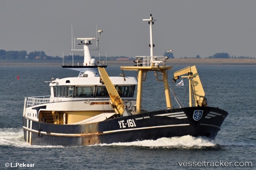
 Ye161 Dingenis Maria
Current Status
Where is the vessel?
Ye161 Dingenis Maria is currently in Near YERSEKE, based on AIS data received less than 1h ago.
Latest AIS update:
Current position: 51.50050° N, 4.05398° E (Near YERSEKE)
Average speed (last 7 days): Loading…
Average speed (last 30 days): Loading…
Vessel profile: Ye161 Dingenis Maria is a Fishing Vessel with dimensions 40m x 40m.
This page combines live AIS, route history, probable destination signals, nearby traffic, and port activity for practical vessel monitoring.
The current position of vessel Ye161 Dingenis Maria is 51.50050 lat / 4.05398 lng. Updated: 2026-04-21 16:21:52 UTCNearest reference points:
- Near YERSEKE
- Near S Heer Arendskerke
- Near Hansweert/Schore
Currently sailing under the flag of Netherlands ![]()
Ye161 Dingenis Maria built in 2002 year
Details:
Live Vessel Ye161 Dingenis Maria Analytics (details, animations, etc.)
Recent AIS points (UTC):
2026-04-21 13:01:53 UTC · 51.55072, 3.94250 · SOG 2.8 kn · COG 166°2026-04-21 13:47:48 UTC · 51.55011, 3.94035 · SOG 2.8 kn · COG 184°
2026-04-21 15:34:12 UTC · 51.50051, 4.05399 · SOG 0 kn · COG 267°
2026-04-21 16:21:52 UTC · 51.50050, 4.05398 · SOG 0 kn · COG 265°