 vesseltracker.com
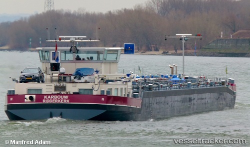
 Karbouw
Current Status
Where is the vessel?
Karbouw is currently in Near HUCKINGEN, based on AIS data received about 1h ago.
Latest AIS update:
Current position: 51.39371° N, 6.74230° E (Near HUCKINGEN)
Average speed (last 7 days): Loading…
Average speed (last 30 days): Loading…
Vessel profile: Karbouw is a Other Tanker with dimensions 110m x 12m.
This page combines live AIS, route history, probable destination signals, nearby traffic, and port activity for practical vessel monitoring.
The current position of vessel Karbouw is 51.39371 lat / 6.74230 lng. Updated: 2026-04-15 05:53:24 UTCNearest reference points:
- Near HUCKINGEN
- Near NEUSS
- Near Emmelsum
Currently sailing under the flag of Netherlands ![]()
Details:
Live Vessel Karbouw Analytics (details, animations, etc.)
Recent AIS points (UTC):
2026-04-14 21:34:35 UTC · 51.84609, 6.14275 · SOG 5.9 kn · COG 109°2026-04-14 23:35:35 UTC · 51.75548, 6.39865 · SOG 5.6 kn · COG 92°
2026-04-15 03:30:35 UTC · 51.55255, 6.67980 · SOG 5.6 kn · COG 205°
2026-04-15 05:53:24 UTC · 51.39371, 6.74230 · SOG 5.3 kn · COG 207°