 vesseltracker.com
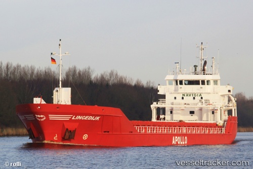
 Lingedijk
Current Status
Where is the vessel?
Lingedijk is currently in Near Herøya, based on AIS data received about 2h ago.
Latest AIS update:
Current position: 59.11903° N, 9.61928° E (Near Herøya)
Average speed (last 7 days): Loading…
Average speed (last 30 days): Loading…
Vessel profile: Lingedijk is a Multi Purpose Carrier with dimensions 90m x 14m.
This page combines live AIS, route history, probable destination signals, nearby traffic, and port activity for practical vessel monitoring.
The current position of vessel Lingedijk is 59.11903 lat / 9.61928 lng. Updated: 2026-03-26 15:45:38 UTCNearest reference points:
- Near Rønningen
- Near SANDEFJORD
- Near Thorøya
Currently sailing under the flag of Netherlands ![]()
Lingedijk built in 2010 year
Deadweight:
4891 tDetails:
Live Vessel Lingedijk Analytics (details, animations, etc.)
Recent AIS points (UTC):
2026-03-26 09:45:38 UTC · 59.11904, 9.61981 · SOG 0 kn · COG 4°2026-03-26 12:21:38 UTC · 59.11907, 9.61982 · SOG 0 kn · COG 4°
2026-03-26 13:54:38 UTC · 59.11905, 9.61927 · SOG 0 kn · COG 4°
2026-03-26 15:45:38 UTC · 59.11903, 9.61928 · SOG 0 kn · COG 4°