 vesseltracker.com
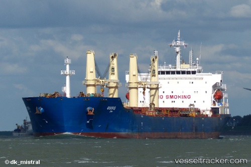
 Osiris
Current Status
Where is the vessel?
Osiris is currently in 59 nm SW of Methoni, based on AIS data received less than 1h ago.
Latest AIS update:
Current position: 36.28928° N, 20.69510° E (59 nm SW of Methoni)
Average speed (last 7 days): Loading…
Average speed (last 30 days): Loading…
Vessel profile: Osiris is a Bulk Carrier with dimensions 190m x 33m.
This page combines live AIS, route history, probable destination signals, nearby traffic, and port activity for practical vessel monitoring.
The current position of vessel Osiris is 36.28928 lat / 20.69510 lng. Updated: 2026-04-06 14:14:02 UTCNearest reference points:
- 23 nm S of Methoni
- 17 nm S of Areópolis
- Near Káto Achaïa
Currently sailing under the flag of Malta ![]()
Osiris built in 2004 year
Deadweight:
53589 tDetails:
Live Vessel Osiris Analytics (details, animations, etc.)
Recent AIS points (UTC):
2026-04-06 07:42:17 UTC · 36.27815, 19.19274 · SOG 11.4 kn · COG 81°2026-04-06 09:35:57 UTC · 36.28842, 19.63743 · SOG 11.4 kn · COG 89°
2026-04-06 12:23:52 UTC · 36.29030, 20.27329 · SOG 10.8 kn · COG -1°
2026-04-06 14:14:02 UTC · 36.28928, 20.69510 · SOG 11.3 kn · COG -1°