 vesseltracker.com
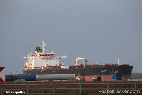
 Namrata
Current Status
Where is the vessel?
Namrata is currently in 16 nm E of Fateh Terminal, based on AIS data received about 2h ago.
Latest AIS update:
Current position: 25.60072° N, 54.81154° E (16 nm E of Fateh Terminal)
Average speed (last 7 days): Loading…
Average speed (last 30 days): Loading…
Vessel profile: Namrata is a Crude Oil Tanker with dimensions 244m x 244m.
This page combines live AIS, route history, probable destination signals, nearby traffic, and port activity for practical vessel monitoring.
The current position of vessel Namrata is 25.60072 lat / 54.81154 lng. Updated: 2026-04-13 01:18:07 UTCNearest reference points:
- 17 nm NW of Free Port
- Near Free Port
- 11 nm SW of Fateh Terminal
Currently sailing under the flag of Malta ![]()
Namrata built in 2008 year
Deadweight:
105830 tDetails:
Live Vessel Namrata Analytics (details, animations, etc.)
Recent AIS points (UTC):
2026-04-12 19:35:40 UTC · 25.60076, 54.81107 · SOG 0 kn · COG 25°2026-04-12 22:11:40 UTC · 25.60039, 54.81144 · SOG 0 kn · COG 22°
2026-04-13 00:17:42 UTC · 25.60061, 54.81115 · SOG 0 kn · COG 31°
2026-04-13 01:18:07 UTC · 25.60072, 54.81154 · SOG 0 kn · COG -1°