 vesseltracker.com
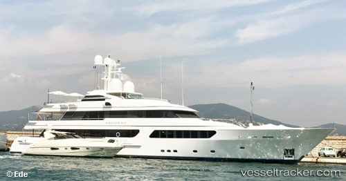
 DREAMS IV
Current Status
Where is the vessel?
DREAMS IV is currently in Near SAINT MANDRIER, based on AIS data received about 1h ago.
Latest AIS update:
Current position: 43.08421° N, 5.93733° E (Near SAINT MANDRIER)
Average speed (last 7 days): Loading…
Average speed (last 30 days): Loading…
Vessel profile: DREAMS IV is a Yacht with dimensions m x m.
This page combines live AIS, route history, probable destination signals, nearby traffic, and port activity for practical vessel monitoring.
The current position of vessel DREAMS IV is 43.08421 lat / 5.93733 lng. Updated: 2026-04-17 17:20:57 UTCNearest reference points:
- Near SAINT MANDRIER
- Near Six-Fours-les-Plages
- Near LA CIOTAT
Currently sailing under the flag of Malta ![]()
Details:
Live Vessel DREAMS IV Analytics (details, animations, etc.)
Recent AIS points (UTC):
2026-04-17 12:25:10 UTC · 43.08420, 5.93730 · SOG 0 kn · COG 114°2026-04-17 14:16:12 UTC · 43.08416, 5.93732 · SOG 0 kn · COG 113°
2026-04-17 15:58:10 UTC · 43.08417, 5.93729 · SOG 0 kn · COG 115°
2026-04-17 17:20:57 UTC · 43.08421, 5.93733 · SOG 0 kn · COG 115°