 vesseltracker.com
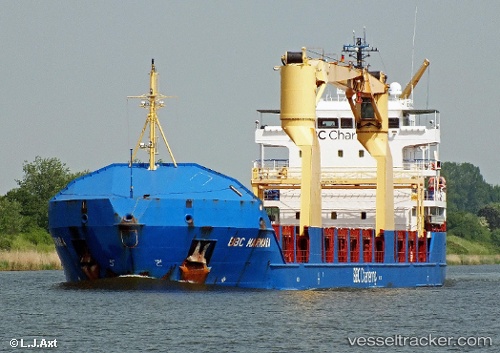
 Bbc Marmara
Current Status
Where is the vessel?
Bbc Marmara is currently in Near Kawana, based on AIS data received about 1h ago.
Latest AIS update:
Current position: 26.86693° S, 153.15698° E (Near Kawana)
Average speed (last 7 days): Loading…
Average speed (last 30 days): Loading…
Vessel profile: Bbc Marmara is a Multi Purpose Carrier with dimensions 115m x 16m.
This page combines live AIS, route history, probable destination signals, nearby traffic, and port activity for practical vessel monitoring.
The current position of vessel Bbc Marmara is -26.86693 lat / 153.15698 lng. Updated: 2026-04-01 21:51:09 UTCNearest reference points:
- Near Minyama
- Near MOOLOOLABA
- Near Bulwer
Currently sailing under the flag of Portugal ![]()
Bbc Marmara built in 2010 year
Deadweight:
6203 tDetails:
Live Vessel Bbc Marmara Analytics (details, animations, etc.)
Recent AIS points (UTC):
2026-04-01 15:27:59 UTC · -26.70167, 153.25333 · SOG 0 kn · COG -1°2026-04-01 17:40:50 UTC · -26.70167, 153.25333 · SOG 0 kn · COG -1°
2026-04-01 19:25:13 UTC · -26.70251, 153.25433 · SOG 0.2 kn · COG 100°
2026-04-01 21:51:09 UTC · -26.86693, 153.15698 · SOG 11 kn · COG 148°