 vesseltracker.com
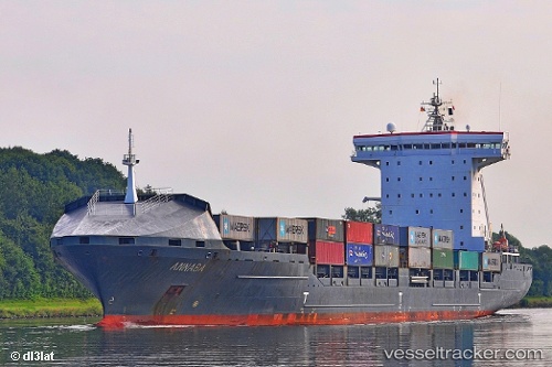
 ANNABA
Current Status
Where is the vessel?
ANNABA is currently in Near Gdynia, based on AIS data received about 1h ago.
Latest AIS update:
Current position: 54.51774° N, 18.65749° E (Near Gdynia)
Average speed (last 7 days): Loading…
Average speed (last 30 days): Loading…
Vessel profile: ANNABA is a Container Ship with dimensions 167m x 26m.
This page combines live AIS, route history, probable destination signals, nearby traffic, and port activity for practical vessel monitoring.
The current position of vessel ANNABA is 54.51774 lat / 18.65749 lng. Updated: 2026-04-18 09:49:30 UTCNearest reference points:
- Near Sopot
- Near Gdynia
- Near Nowy Port/Gdansk
Currently sailing under the flag of Portugal (MAR) ![]()
ANNABA built in 2006 year
Deadweight:
20614 tDetails:
Live Vessel ANNABA Analytics (details, animations, etc.)
Recent AIS points (UTC):
2026-04-18 04:19:35 UTC · 54.54386, 18.50497 · SOG 0 kn · COG 120°2026-04-18 06:16:32 UTC · 54.54384, 18.50498 · SOG 0 kn · COG 119°
2026-04-18 07:57:32 UTC · 54.54388, 18.50497 · SOG 0 kn · COG 119°
2026-04-18 09:49:30 UTC · 54.51774, 18.65749 · SOG 0.5 kn · COG 356°