 vesseltracker.com
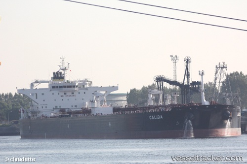
 Calida
Current Status
Where is the vessel?
Calida is currently in 37 nm SE of Fisher Island, Miami, based on AIS data received about 21h ago.
Latest AIS update:
Current position: 25.44266° N, 79.54993° W (37 nm SE of Fisher Island, Miami)
Average speed (last 7 days): Loading…
Average speed (last 30 days): Loading…
Vessel profile: Calida is a Crude Oil Tanker with dimensions 249m x 44m.
This page combines live AIS, route history, probable destination signals, nearby traffic, and port activity for practical vessel monitoring.
The current position of vessel Calida is 25.44266 lat / -79.54993 lng. Updated: 2026-04-10 07:31:17 UTCNearest reference points:
- 44 nm E of Surfside
- Near Fisher Island, Miami
- 11 nm SE of Cutler Bay
Currently sailing under the flag of Malta ![]()
Calida built in 2012 year
Deadweight:
115812 tDetails:
Live Vessel Calida Analytics (details, animations, etc.)
Recent AIS points (UTC):
2026-04-10 02:17:40 UTC · 26.33043, -78.97314 · SOG 13.9 kn · COG 286°2026-04-10 04:15:50 UTC · 26.13962, -79.39531 · SOG 13 kn · COG 202°
2026-04-10 06:25:58 UTC · 25.67419, -79.49121 · SOG 13.3 kn · COG 191°
2026-04-10 07:31:17 UTC · 25.44266, -79.54993 · SOG 12.9 kn · COG 192°