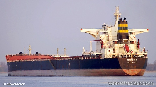
.
vessel Madeira IMO: 9355161, Bulk Carrier
vesseltracker.com
Vessel Madeira IMO: 9355161, MMSI: 256668000 Bulk Carrier

callsign: 9HAA9
size: 45x292

Live AIS position: UTC. Near Al Qantarah El Sharqiyya), updated 2022-12-07 13:22:18 UTC.

Find the position of the vessel Madeira on the map. The latter are known coordinates and path.

marine traffic ship tracker show on live map

The current position of vessel Madeira is 30.76568 lat / 32.33012 lng. Updated: 2022-12-07 13:22:18 UTC
Details:


Last coordinates of the vessel:
2022-12-07 13:22:18 UTC, 30.76568, 32.33012, course: 346, speed: 10.6

Track of the vessel in the last 28 days


Most frequent ports a vessels calls at Madeira (256668000):

Uskudar, traffic: 7
Istanbul, traffic: 7
Gelibolu, traffic: 6
Canakkale, traffic: 5
Bur Ibrahim, traffic: 3
Newcastle, traffic: 2
Piraeus, traffic: 2
Port Kembla, traffic: 2
Botas, traffic: 2
Tarragona, traffic: 2
Iskenderun, traffic: 2
Wilson Promontory, traffic: 2
Ayn Sukhnah, traffic: 1
Port Said, traffic: 1
Ra’S Shukhayr, traffic: 1

Link to the map:


Find another ship

Madeira (256668000) last ports (portcalls and passsages)

Ayn Sukhnah | 2022-12-05 23:13:24
Bur Ibrahim | 2022-10-15 16:11:30
Murmansk | 2022-09-21 10:50:20
Uskudar | 2022-09-02 04:41:16
Gelibolu | 2022-09-01 10:12:20
Canakkale | 2022-09-01 07:39:38
Bur Ibrahim | 2022-08-29 04:59:00
Singapore | 2022-08-11 01:22:40
Ra’S Shukhayr | 2022-05-16 01:10:29
Bur Ibrahim | 2022-05-15 14:01:15
Port Said | 2022-05-15 04:24:32
Gelibolu | 2022-05-12 04:27:35
Uskudar | 2022-05-11 07:32:58
Uskudar | 2022-04-16 09:25:20
Gelibolu | 2022-04-15 15:20:13
Piraeus | 2022-04-13 21:25:58
Tarragona | 2022-03-26 15:45:00
Canakkale | 2022-03-21 15:35:15
Uskudar | 2022-03-11 12:15:09
Iskenderun | 2022-03-01 09:45:21
Canakkale | 2022-02-26 12:50:06
Gelibolu | 2022-02-26 06:24:49
Uskudar | 2022-02-06 12:35:09
Botas | 2022-01-30 04:06:57
Wilson Promontory | 2021-12-30 00:55:18
Newcastle | 2021-12-27 01:16:17
Port Kembla | 2021-12-06 21:30:11