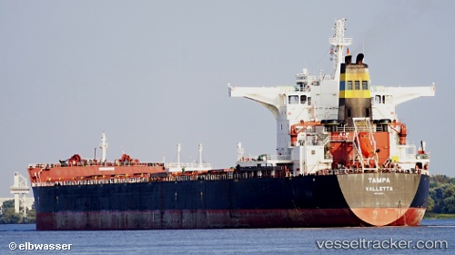
.
Vessel photo of Tampa (IMO 9363027) vesseltracker.com

Tampa

Vessel type: Bulk Carrier | IMO: 9363027 | MMSI: MMSI: 256974000
Call sign: 9HHA9 | Dimensions: 45 m x 292 m
Current Status

Where is the vessel?

Tampa is currently in Near Gdynia, based on AIS data received about 1235d ago.

Latest AIS update:

Current position: 54.53220° N, 18.55186° E (Near Gdynia)

Average speed (last 7 days): Loading…

Average speed (last 30 days): Loading…

Vessel profile: Tampa is a Bulk Carrier with dimensions 45m x 292m.

This page combines live AIS, route history, probable destination signals, nearby traffic, and port activity for practical vessel monitoring.

The current position of vessel Tampa is 54.53220 lat / 18.55186 lng. Updated: 2022-11-21 10:22:35 UTC
Nearest reference points:
  • Near Gdynia
  • Near Sopot
  • Near Nowy Port/Gdansk
Details:

Live Vessel Tampa Analytics (details, animations, etc.)


Recent AIS points (UTC):
2022-11-21 10:22:35 UTC · 54.53220, 18.55186 · SOG 0 kn · COG 81°

Track of the vessel in the last 60 days


UTC: --
Start: -- Track timeline (UTC) End: --
Encountered: --


Link to the map:


Find another ship

Tampa (256974000) last ports (portcalls and passsages)

Gdynia | 2022-11-20 00:01:43
Terneuzen | 2022-11-13 17:45:21
Zeebrugge | 2022-11-13 15:03:41
Strait Of Gibraltar | 2022-11-07 08:20:23
Bur Ibrahim | 2022-10-30 05:16:39
Ra’S Shukhayr | 2022-10-29 01:55:53
Ra’S Shukhayr | 2022-08-06 04:23:09
Bur Ibrahim | 2022-08-05 16:49:48
Skagens Odde | 2022-07-20 22:53:59
Korsor | 2022-07-20 07:35:34
Ust-Luga | 2022-07-13 10:35:39
Skagens Odde | 2022-07-10 01:39:01
Port Said | 2022-06-25 19:53:59
Bur Ibrahim | 2022-06-25 07:34:21
Vishakhapatnam | 2022-06-05 04:11:53
Vishakhapatnam | 2022-06-01 04:11:30
Selat Lombok | 2022-04-15 03:31:23
Port Headland | 2022-04-09 18:20:13
Selat Lombok | 2022-04-04 17:28:11
Sambu | 2022-03-03 15:50:32
Singapore | 2022-03-03 15:10:03
Port Elizabeth | 2022-02-06 00:00:08
Rio De Janeiro | 2021-12-28 17:30:21