 vesseltracker.com
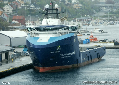
 Troms Arcturus
Current Status
Where is the vessel?
Troms Arcturus is currently in 15 nm NW of Veiholmen, based on AIS data received less than 1h ago.
Latest AIS update:
Current position: 63.68431° N, 7.51329° E (15 nm NW of Veiholmen)
Average speed (last 7 days): Loading…
Average speed (last 30 days): Loading…
Vessel profile: Troms Arcturus is a Offshore Tug Supply Ship with dimensions 95m x 95m.
This page combines live AIS, route history, probable destination signals, nearby traffic, and port activity for practical vessel monitoring.
The current position of vessel Troms Arcturus is 63.68431 lat / 7.51329 lng. Updated: 2026-04-05 23:57:00 UTCNearest reference points:
- Near Smøla
- Near Kristiansund
- Near Halsa
Currently sailing under the flag of Norway ![]()
Troms Arcturus built in 2014 year
Deadweight:
5580 tDetails:
Live Vessel Troms Arcturus Analytics (details, animations, etc.)
Recent AIS points (UTC):
2026-04-05 12:58:14 UTC · 65.24500, 7.33333 · SOG 8 kn · COG -1°2026-04-05 15:46:15 UTC · 64.88833, 7.37500 · SOG 8 kn · COG -1°
2026-04-05 21:30:42 UTC · 64.03147, 7.51168 · SOG 9 kn · COG 182°
2026-04-05 23:57:00 UTC · 63.68431, 7.51329 · SOG 8 kn · COG 181°