 vesseltracker.com
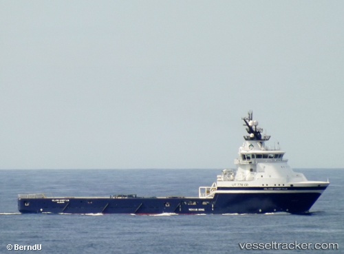
 Island Chieftain
Current Status
Where is the vessel?
Island Chieftain is currently in Near PETERHEAD, based on AIS data received about 1h ago.
Latest AIS update:
Current position: 57.49401° N, 1.78699° W (Near PETERHEAD)
Average speed (last 7 days): Loading…
Average speed (last 30 days): Loading…
Vessel profile: Island Chieftain is a Offshore Tug Supply Ship with dimensions 94m x 20m.
This page combines live AIS, route history, probable destination signals, nearby traffic, and port activity for practical vessel monitoring.
The current position of vessel Island Chieftain is 57.49401 lat / -1.78699 lng. Updated: 2026-04-03 05:34:46 UTCNearest reference points:
- Near PETERHEAD
- Near Peterhead
- Near Aberdeen
Currently sailing under the flag of Norway ![]()
Island Chieftain built in 2009 year
Deadweight:
4100 tDetails:
Live Vessel Island Chieftain Analytics (details, animations, etc.)
Recent AIS points (UTC):
2026-04-02 23:53:10 UTC · 57.48477, -1.71503 · SOG 4.6 kn · COG 214°2026-04-03 02:19:30 UTC · 57.49391, -1.78696 · SOG 0 kn · COG 133°
2026-04-03 03:28:17 UTC · 57.49397, -1.78706 · SOG 0 kn · COG 132°
2026-04-03 05:34:46 UTC · 57.49401, -1.78699 · SOG 0.1 kn · COG 131°