 vesseltracker.com
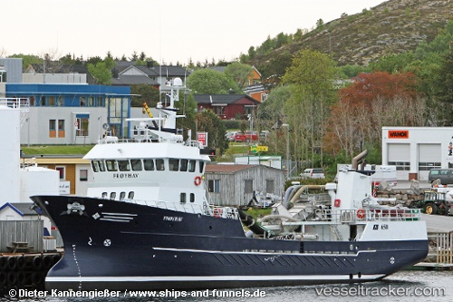
 RONJA ODE
Current Status
Where is the vessel?
RONJA ODE is currently in Near Vartdal, based on AIS data received less than 1h ago.
Latest AIS update:
Current position: 62.30190° N, 6.08460° E (Near Vartdal)
Average speed (last 7 days): Loading…
Average speed (last 30 days): Loading…
Vessel profile: RONJA ODE is a Fish Carrier with dimensions m x m.
This page combines live AIS, route history, probable destination signals, nearby traffic, and port activity for practical vessel monitoring.
The current position of vessel RONJA ODE is 62.30190 lat / 6.08460 lng. Updated: 2026-04-19 05:38:05 UTCNearest reference points:
- Near Alesund
- Near Fiskarstrand
- Near Gjøsundet
Currently sailing under the flag of Norway ![]()
Details:
Live Vessel RONJA ODE Analytics (details, animations, etc.)
Recent AIS points (UTC):
2026-04-18 23:52:35 UTC · 62.30191, 6.08461 · SOG 0 kn · COG 50°2026-04-19 01:23:16 UTC · 62.30192, 6.08462 · SOG 0 kn · COG 50°
2026-04-19 04:05:16 UTC · 62.30191, 6.08456 · SOG 0 kn · COG 49°
2026-04-19 05:38:05 UTC · 62.30190, 6.08460 · SOG 0 kn · COG 49°