 vesseltracker.com
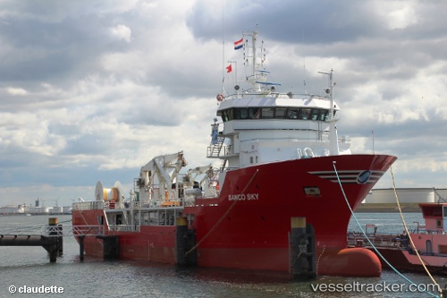
 OCEAN SKY
Current Status
Where is the vessel?
OCEAN SKY is currently in Near Odudu Terminal, based on AIS data received less than 1h ago.
Latest AIS update:
Current position: 4.05970° N, 7.80005° E (Near Odudu Terminal)
Average speed (last 7 days): Loading…
Average speed (last 30 days): Loading…
Vessel profile: OCEAN SKY is a Research/Survey Vessel with dimensions m x m.
This page combines live AIS, route history, probable destination signals, nearby traffic, and port activity for practical vessel monitoring.
The current position of vessel OCEAN SKY is 4.05970 lat / 7.80005 lng. Updated: 2026-04-19 01:24:29 UTCNearest reference points:
- Near Odudu Terminal
- 12 nm SE of Okono
- Near Ima
Currently sailing under the flag of Norway ![]()
Details:
Live Vessel OCEAN SKY Analytics (details, animations, etc.)
Recent AIS points (UTC):
2026-04-18 19:23:59 UTC · 4.01764, 7.77743 · SOG 4.5 kn · COG 43°2026-04-18 21:42:08 UTC · 3.98403, 7.69309 · SOG 4.5 kn · COG 266°
2026-04-18 23:51:20 UTC · 4.01118, 7.75069 · SOG 4.6 kn · COG 48°
2026-04-19 01:24:29 UTC · 4.05970, 7.80005 · SOG 4.5 kn · COG 46°