 vesseltracker.com
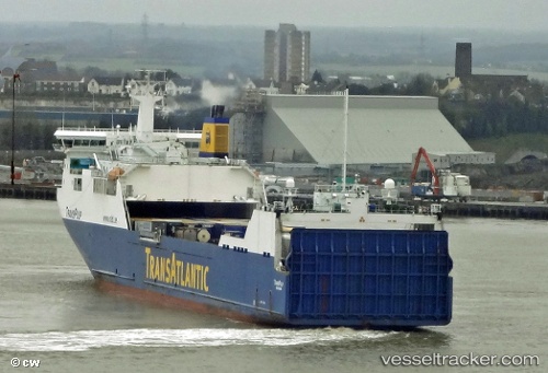
 Thuleland
Current Status
Where is the vessel?
Thuleland is currently in Near SHOTLEY, based on AIS data received about 1h ago.
Latest AIS update:
Current position: 51.94819° N, 1.24262° E (Near SHOTLEY)
Average speed (last 7 days): Loading…
Average speed (last 30 days): Loading…
Vessel profile: Thuleland is a Ro Ro Cargo Ship with dimensions 191m x 26m.
This page combines live AIS, route history, probable destination signals, nearby traffic, and port activity for practical vessel monitoring.
The current position of vessel Thuleland is 51.94819 lat / 1.24262 lng. Updated: 2026-03-29 01:23:04 UTCNearest reference points:
- Near Harwich
- Near SHOTLEY
- Near Levington
Currently sailing under the flag of Sweden ![]()
Thuleland built in 2006 year
Deadweight:
13800 tDetails:
Live Vessel Thuleland Analytics (details, animations, etc.)
Recent AIS points (UTC):
2026-03-28 19:35:38 UTC · 51.94818, 1.24263 · SOG 0.1 kn · COG 265°2026-03-28 21:37:29 UTC · 51.94818, 1.24263 · SOG 0 kn · COG 265°
2026-03-29 00:15:49 UTC · 51.94820, 1.24263 · SOG 0 kn · COG 266°
2026-03-29 01:23:04 UTC · 51.94819, 1.24262 · SOG 0 kn · COG 265°