 vesseltracker.com
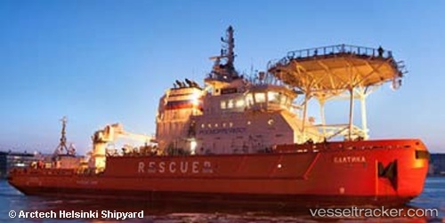
 BALTIKA
Current Status
Where is the vessel?
BALTIKA is currently in 44 nm NE of Nogliki, based on AIS data received about 1h ago.
Latest AIS update:
Current position: 52.46833° N, 143.65334° E (44 nm NE of Nogliki)
Average speed (last 7 days): Loading…
Average speed (last 30 days): Loading…
Vessel profile: BALTIKA is a Icebreaker with dimensions 76m x 20m.
This page combines live AIS, route history, probable destination signals, nearby traffic, and port activity for practical vessel monitoring.
The current position of vessel BALTIKA is 52.46833 lat / 143.65334 lng. Updated: 2026-03-29 19:37:57 UTCNearest reference points:
- 46 nm SE of Widuchowa
- 37 nm N of Nogliki
- 37 nm E of Widuchowa
Currently sailing under the flag of Russia ![]()
BALTIKA built in 2015 year
Deadweight:
1150 tDetails:
Live Vessel BALTIKA Analytics (details, animations, etc.)
Recent AIS points (UTC):
2026-03-29 13:26:50 UTC · 52.46944, 143.65161 · SOG 0.1 kn · COG 179°2026-03-29 15:19:23 UTC · 52.46948, 143.65169 · SOG 0.1 kn · COG 178°
2026-03-29 18:13:54 UTC · 52.46833, 143.65167 · SOG 0 kn · COG -1°
2026-03-29 19:37:57 UTC · 52.46833, 143.65334 · SOG 0 kn · COG -1°