 vesseltracker.com
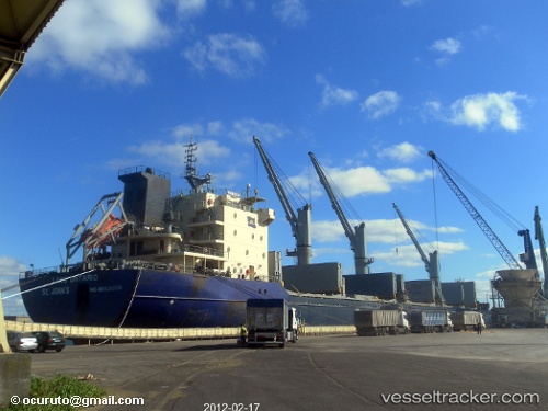
Lake Ontario
Current StatusWhere is the vessel?
Lake Ontario is currently in Near Douala, based on AIS data received about 3h ago.
Latest AIS update:
Current position: 4.04451° N, 9.68145° E (Near Douala)
Average speed (last 7 days): Loading…
Average speed (last 30 days): Loading…
Vessel profile: Lake Ontario is a Bulk Carrier with dimensions 23m x 184m.
This page combines live AIS, route history, probable destination signals, nearby traffic, and port activity for practical vessel monitoring.
The current position of vessel Lake Ontario is 4.04451 lat / 9.68145 lng. Updated: 2026-04-18 06:39:09 UTCNearest reference points:
- Near Victoria
- Near Moudi Terminal
- Near Calabar
Details:
Live Vessel Lake Ontario Analytics (details, animations, etc.)
Recent AIS points (UTC):
2026-04-18 02:21:10 UTC · 4.04448, 9.68150 · SOG 0 kn · COG 58°2026-04-18 04:54:12 UTC · 4.04447, 9.68150 · SOG 0 kn · COG 59°
2026-04-18 06:39:09 UTC · 4.04451, 9.68145 · SOG 0 kn · COG 59°
2026-04-18 06:39:09 UTC · 4.04451, 9.68145 · SOG 0 kn · COG 59°