 vesseltracker.com
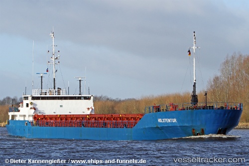
 Holstentor
Current Status
Where is the vessel?
Holstentor is currently in Near Town Quays/Drogheda, based on AIS data received about 1h ago.
Latest AIS update:
Current position: 53.71333° N, 6.29333° E (Near Town Quays/Drogheda)
Average speed (last 7 days): Loading…
Average speed (last 30 days): Loading…
Vessel profile: Holstentor is a Multi Purpose Carrier with dimensions 87m x 87m.
This page combines live AIS, route history, probable destination signals, nearby traffic, and port activity for practical vessel monitoring.
The current position of vessel Holstentor is 53.71333 lat / 6.29333 lng. Updated: 2026-03-30 03:43:38 UTCNearest reference points:
- 14 nm NW of Town Quays/Drogheda
- Near Borkum
- Near Hoogkerk
Currently sailing under the flag of Antigua Barbuda ![]()
Holstentor built in 1989 year
Deadweight:
3432 tDetails:
Live Vessel Holstentor Analytics (details, animations, etc.)
Recent AIS points (UTC):
2026-03-29 21:37:39 UTC · 53.42787, 4.88659 · SOG 8.3 kn · COG 70°2026-03-29 23:49:59 UTC · 53.53529, 5.37014 · SOG 8.3 kn · COG 74°
2026-03-30 01:43:00 UTC · 53.61716, 5.79742 · SOG 8.9 kn · COG 73°
2026-03-30 03:43:38 UTC · 53.71333, 6.29333 · SOG 9 kn · COG -1°