 vesseltracker.com
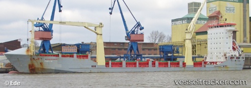
Liloa Ii
Current StatusWhere is the vessel?
Liloa Ii is currently in 82 nm SW of Vanua Mbalavu, based on AIS data received less than 1h ago.
Latest AIS update:
Current position: 18.26542° S, 179.88628° W (82 nm SW of Vanua Mbalavu)
Average speed (last 7 days): Loading…
Average speed (last 30 days): Loading…
Vessel profile: Liloa Ii is a Multi Purpose Carrier with dimensions 18m x 118m.
This page combines live AIS, route history, probable destination signals, nearby traffic, and port activity for practical vessel monitoring.
The current position of vessel Liloa Ii is -18.26542 lat / -179.88628 lng. Updated: 2026-04-07 16:28:04 UTCDetails:
Live Vessel Liloa Ii Analytics (details, animations, etc.)
Recent AIS points (UTC):
2026-04-07 10:16:17 UTC · -18.29270, -179.93057 · SOG 0.8 kn · COG 21°2026-04-07 11:33:49 UTC · -18.28033, -179.92184 · SOG 0.4 kn · COG 22°
2026-04-07 13:35:46 UTC · -18.26687, -179.90863 · SOG 0.8 kn · COG 2°
2026-04-07 16:28:04 UTC · -18.26542, -179.88628 · SOG 1 kn · COG 354°