 vesseltracker.com
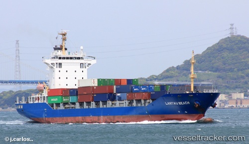
 Lantau Beach
Current Status
Where is the vessel?
Lantau Beach is currently in 46 nm W of Ikitsuki, based on AIS data received less than 1h ago.
Latest AIS update:
Current position: 33.16667° N, 128.55333° E (46 nm W of Ikitsuki)
Average speed (last 7 days): Loading…
Average speed (last 30 days): Loading…
Vessel profile: Lantau Beach is a Container Ship with dimensions 143m x 23m.
This page combines live AIS, route history, probable destination signals, nearby traffic, and port activity for practical vessel monitoring.
The current position of vessel Lantau Beach is 33.16667 lat / 128.55333 lng. Updated: 2026-04-08 07:16:35 UTCNearest reference points:
- 33 nm W of IZUHARA
- 25 nm S of Kukdo
- 35 nm E of Geomundo
Currently sailing under the flag of Antigua Barbuda ![]()
Lantau Beach built in 2007 year
Deadweight:
12829 tDetails:
Live Vessel Lantau Beach Analytics (details, animations, etc.)
Recent AIS points (UTC):
2026-04-08 01:30:39 UTC · 33.72677, 129.99660 · SOG 13.9 kn · COG 237°2026-04-08 03:19:31 UTC · 33.55333, 129.54167 · SOG 13 kn · COG -1°
2026-04-08 05:25:28 UTC · 33.36167, 129.01334 · SOG 13 kn · COG -1°
2026-04-08 07:16:35 UTC · 33.16667, 128.55333 · SOG 14 kn · COG -1°