 vesseltracker.com
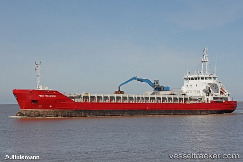
 Feed Trondheim
Current Status
Where is the vessel?
Feed Trondheim is currently in Near KARMOY, based on AIS data received about 1d ago.
Latest AIS update:
Current position: 59.31200° N, 5.32883° E (Near KARMOY)
Average speed (last 7 days): Loading…
Average speed (last 30 days): Loading…
Vessel profile: Feed Trondheim is a Multi Purpose Carrier with dimensions 100m x 16m.
This page combines live AIS, route history, probable destination signals, nearby traffic, and port activity for practical vessel monitoring.
The current position of vessel Feed Trondheim is 59.31200 lat / 5.32883 lng. Updated: 2026-04-10 07:27:46 UTCNearest reference points:
- Near HUSOYA
- Near Storøya
- Near Valevåg
Currently sailing under the flag of Antigua Barbuda ![]()
Feed Trondheim built in 2002 year
Deadweight:
4633 tDetails:
Live Vessel Feed Trondheim Analytics (details, animations, etc.)
Recent AIS points (UTC):
2026-04-10 02:23:47 UTC · 58.48300, 5.48383 · SOG 9.3 kn · COG 349°2026-04-10 03:49:26 UTC · 58.70283, 5.38400 · SOG 9 kn · COG 357°
2026-04-10 05:57:58 UTC · 59.05133, 5.34050 · SOG 9.8 kn · COG 7°
2026-04-10 07:27:46 UTC · 59.31200, 5.32883 · SOG 11 kn · COG 357°