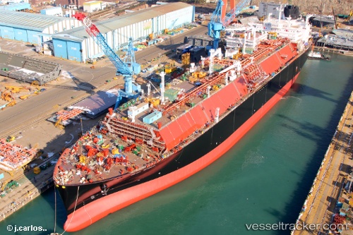
.
Vessel photo of Sean Spirit (IMO 9781918) vesseltracker.com

BS flag Sean Spirit

Vessel type: Lng Tanker | IMO: 9781918 | MMSI: MMSI: 311000665
Call sign: C6DG2 | Dimensions: 294 m x 294 m
Current Status

Where is the vessel?

Sean Spirit is currently in 52 nm NW of Port Clements, based on AIS data received about 2h ago.

Latest AIS update:

Current position: 54.36003° N, 133.07948° W (52 nm NW of Port Clements)

Average speed (last 7 days): Loading…

Average speed (last 30 days): Loading…

Vessel profile: Sean Spirit is a Lng Tanker with dimensions 294m x 294m.

This page combines live AIS, route history, probable destination signals, nearby traffic, and port activity for practical vessel monitoring.

The current position of vessel Sean Spirit is 54.36003 lat / -133.07948 lng. Updated: 2026-04-07 23:45:51 UTC
Nearest reference points:
  • 15 nm N of Port Clements
  • Near Queen Charlotte
  • Near Ward Cove

Currently sailing under the flag of Bahamas BS flag

Details:

Live Vessel Sean Spirit Analytics (details, animations, etc.)


Recent AIS points (UTC):
2026-04-07 17:25:40 UTC · 54.27862, -131.04356 · SOG 10.4 kn · COG 357°
2026-04-07 20:01:21 UTC · 54.35315, -131.82996 · SOG 12.4 kn · COG 265°
2026-04-07 22:04:32 UTC · 54.32528, -132.49651 · SOG 11 kn · COG 274°
2026-04-07 23:45:51 UTC · 54.36003, -133.07948 · SOG 12.7 kn · COG 273°

Track of the vessel in the last 60 days


UTC: --
Start: -- Track timeline (UTC) End: --
Encountered: --


Link to the map:


Find another ship

Sean_Spirit (311000665) last ports (portcalls and passsages)

Yokohama | 2025-08-28 02:59:16
KIMITSU | 2025-08-26 23:35:42
Yokosuka | 2025-08-26 22:58:55
BATU AMPAR | 2025-08-17 07:21:01
BUKOM ISLAND | 2025-08-16 07:15:49
RAS LAFFAN | 2025-08-06 00:36:25
Port Louis | 2025-07-14 05:24:53
BRIELLE | 2025-05-24 20:40:57
Urdiales | 2025-04-16 05:03:53
Strait Of Gibraltar | 2025-03-21 22:58:20
Port Said | 2025-03-17 13:13:47
ISMAILIA | 2025-03-17 09:38:25
SUEZ CANAL | 2025-03-17 08:00:51
AL ADABIYAH | 2025-03-17 03:37:22
RAS SHUKHEIR | 2025-03-16 05:36:01
AQABA INDUSTRIAL | 2025-03-15 04:54:27
AQABA INDUSTRIAL | 2025-03-11 03:39:51
RAS SHUKHEIR | 2025-03-09 20:37:54
Ras Gharib | 2025-03-09 19:20:40
AL ADABIYAH | 2025-03-09 12:30:54
SUEZ PORT | 2025-03-09 12:18:09
SUEZ CANAL | 2025-03-09 09:39:18
ISMAILIA | 2025-03-09 08:23:07
Port Said | 2025-03-09 02:47:01
TANGER MED | 2025-02-27 11:51:25
Strait Of Gibraltar | 2025-02-27 10:28:36
Port Louis | 2025-01-16 03:52:42
BUKOM ISLAND | 2025-01-08 03:36:59
BATU AMPAR | 2025-01-08 02:43:43
PENGERANG | 2025-01-08 00:51:37
Map Ta Phut | 2025-01-04 22:59:17
PENGERANG | 2024-12-30 04:49:04
TANAH MERAH | 2024-12-30 03:54:20
PULAU SAMBU | 2024-12-30 03:23:38
BUKOM ISLAND | 2024-12-09 00:30:35
BUKOM ISLAND | 2024-12-05 00:11:51
JURONG ISLAND | 2024-11-08 06:49:19
BUKOM ISLAND | 2024-11-08 06:12:37
BATU AMPAR | 2024-11-08 04:48:01
PENGERANG | 2024-11-08 04:13:25
Map Ta Phut | 2024-11-04 22:59:16
Sambu | 2024-10-22 05:45:15
Yokohama | 2024-09-25 05:59:24
Singapore | 2024-08-21 22:40:06
Galle | 2024-07-21 01:56:17
Cochin | 2024-07-03 00:42:19
Singapore | 2024-06-02 11:44:56
Christiansted | 2024-02-29 12:07:42
Limetree Bay | 2024-02-29 10:44:59
Strait Of Gibraltar | 2024-01-31 00:47:01
Singapore | 2023-11-06 15:24:23
Map Ta Phut | 2023-11-01 01:15:50
Sambu | 2023-10-11 04:45:34
Cochin | 2023-09-07 02:09:29
Mina Saud | 2023-08-03 22:18:56
Mina Saud | 2023-05-29 21:22:58
Ra’S Shukhayr | 2023-04-12 23:02:00
Bur Ibrahim | 2023-04-12 14:21:03
Port Said | 2023-04-12 05:26:48
Kalamai | 2023-04-09 10:36:10
Port Said | 2023-03-23 14:36:56
Bur Ibrahim | 2023-03-23 05:38:22
Yokohama | 2023-02-03 03:06:02
Singapore | 2022-08-07 08:02:43
Yokosuka | 2022-06-29 04:26:33
Yokohama | 2022-06-28 01:28:55
Singapore | 2022-05-13 01:15:07
Bur Ibrahim | 2022-01-30 17:05:08
Salamis | 2022-01-25 10:55:13
Megara | 2022-01-25 05:35:21
Strait Of Gibraltar | 2021-12-22 10:55:08