 vesseltracker.com
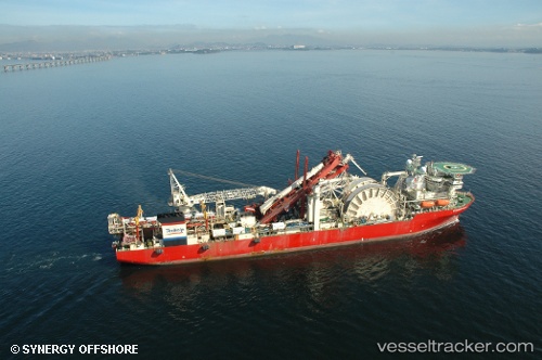
 Deep Blue
Current Status
Where is the vessel?
Deep Blue is currently in Near Ardersier, based on AIS data received about 1h ago.
Latest AIS update:
Current position: 57.59930° N, 4.00549° W (Near Ardersier)
Average speed (last 7 days): Loading…
Average speed (last 30 days): Loading…
Vessel profile: Deep Blue is a Pipe Layer with dimensions 206m x 32m.
This page combines live AIS, route history, probable destination signals, nearby traffic, and port activity for practical vessel monitoring.
The current position of vessel Deep Blue is 57.59930 lat / -4.00549 lng. Updated: 2026-04-05 10:12:05 UTCNearest reference points:
- Near Fortrose
- Near Inverness
- Near Findhorn
Currently sailing under the flag of Bahamas ![]()
Deep Blue built in 2001 year
Deadweight:
25449 tDetails:
Live Vessel Deep Blue Analytics (details, animations, etc.)
Recent AIS points (UTC):
2026-04-05 03:26:57 UTC · 57.59930, -4.00550 · SOG 0 kn · COG 299°2026-04-05 05:35:57 UTC · 57.59932, -4.00553 · SOG 0 kn · COG 299°
2026-04-05 07:44:56 UTC · 57.59930, -4.00549 · SOG 0 kn · COG 299°
2026-04-05 10:12:05 UTC · 57.59930, -4.00549 · SOG 0 kn · COG 299°