 vesseltracker.com
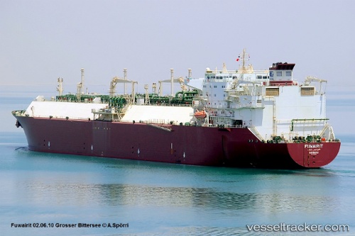
 Fuwairit
Current Status
Where is the vessel?
Fuwairit is currently in 29 nm N of Mirfa, based on AIS data received less than 1h ago.
Latest AIS update:
Current position: 25.94354° N, 53.53739° E (29 nm N of Mirfa)
Average speed (last 7 days): Loading…
Average speed (last 30 days): Loading…
Vessel profile: Fuwairit is a Lng Tanker with dimensions 278m x 42m.
This page combines live AIS, route history, probable destination signals, nearby traffic, and port activity for practical vessel monitoring.
The current position of vessel Fuwairit is 25.94354 lat / 53.53739 lng. Updated: 2026-04-20 01:01:42 UTCNearest reference points:
- Near Jazireh-Ye Lavan
- 21 nm NE of Halul Island
- 11 nm SW of Fateh Terminal
Currently sailing under the flag of Bahamas ![]()
Fuwairit built in 2004 year
Deadweight:
74067 tDetails:
Live Vessel Fuwairit Analytics (details, animations, etc.)
Recent AIS points (UTC):
2026-04-19 22:18:53 UTC · 25.94828, 53.56187 · SOG 0.3 kn · COG 22°2026-04-19 22:22:43 UTC · 25.94815, 53.56146 · SOG 0.3 kn · COG 22°
2026-04-19 23:55:42 UTC · 25.94385, 53.54792 · SOG 0.5 kn · COG 28°
2026-04-20 01:01:42 UTC · 25.94354, 53.53739 · SOG 0.5 kn · COG 45°