 vesseltracker.com
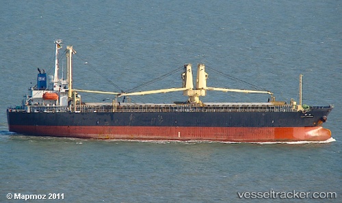
 YORK 17
Current Status
Where is the vessel?
YORK 17 is currently in 45 nm SE of Rio Tuba, based on AIS data received less than 1h ago.
Latest AIS update:
Current position: 7.94167° N, 117.90833° E (45 nm SE of Rio Tuba)
Average speed (last 7 days): Loading…
Average speed (last 30 days): Loading…
Vessel profile: YORK 17 is a General Cargo Ship with dimensions 117m x 19m.
This page combines live AIS, route history, probable destination signals, nearby traffic, and port activity for practical vessel monitoring.
The current position of vessel YORK 17 is 7.94167 lat / 117.90833 lng. Updated: 2026-04-14 01:26:39 UTCNearest reference points:
- 35 nm SE of Brookes Point, Palawan
- 70 nm W of Puerto Princesa
- 66 nm W of Jolo
Currently sailing under the flag of Belize ![]()
YORK 17 built in 2000 year
Deadweight:
11612 tDetails:
Live Vessel YORK 17 Analytics (details, animations, etc.)
Recent AIS points (UTC):
2026-04-13 19:23:08 UTC · 7.65167, 116.96333 · SOG 10 kn · COG -1°2026-04-13 21:56:18 UTC · 7.95833, 117.25167 · SOG 10 kn · COG -1°
2026-04-13 23:41:26 UTC · 7.95167, 117.58167 · SOG 11 kn · COG -1°
2026-04-14 01:26:39 UTC · 7.94167, 117.90833 · SOG 11 kn · COG -1°