 vesseltracker.com
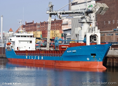
 Wilson Hawk
Current Status
Where is the vessel?
Wilson Hawk is currently in Near PARKHAVEN, based on AIS data received about 2d ago.
Latest AIS update:
Current position: 51.90365° N, 4.47320° E (Near PARKHAVEN)
Average speed (last 7 days): Loading…
Average speed (last 30 days): Loading…
Vessel profile: Wilson Hawk is a Multi Purpose Carrier with dimensions 91m x 14m.
This page combines live AIS, route history, probable destination signals, nearby traffic, and port activity for practical vessel monitoring.
The current position of vessel Wilson Hawk is 51.90365 lat / 4.47320 lng. Updated: 2026-04-09 10:32:58 UTCNearest reference points:
- Near PARKHAVEN
- Near Rotterdam
- Near ROTTERDAM CENTRUM
Currently sailing under the flag of Barbados ![]()
Wilson Hawk built in 1994 year
Deadweight:
4284 tDetails:
Live Vessel Wilson Hawk Analytics (details, animations, etc.)
Recent AIS points (UTC):
2026-04-09 09:41:20 UTC · 51.90360, 4.47323 · SOG 0 kn · COG 59°2026-04-09 10:32:58 UTC · 51.90365, 4.47320 · SOG 0 kn · COG -1°
2026-04-09 10:32:58 UTC · 51.90365, 4.47320 · SOG 0 kn · COG -1°
2026-04-09 10:32:58 UTC · 51.90365, 4.47320 · SOG 0 kn · COG -1°