 vesseltracker.com
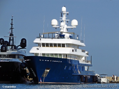
 Polar Star
Current Status
Where is the vessel?
Polar Star is currently in 253 nm N of Bartolome Island, based on AIS data received about 1d ago.
Latest AIS update:
Current position: 3.84825° N, 89.74618° W (253 nm N of Bartolome Island)
Average speed (last 7 days): Loading…
Average speed (last 30 days): Loading…
Vessel profile: Polar Star is a Service Ship with dimensions 65m x 13m.
This page combines live AIS, route history, probable destination signals, nearby traffic, and port activity for practical vessel monitoring.
The current position of vessel Polar Star is 3.84825 lat / -89.74618 lng. Updated: 2026-04-10 07:15:40 UTCNearest reference points:
- 122 nm N of Caleta Tagus
Currently sailing under the flag of Cayman Is ![]()
Polar Star built in 2005 year
Details:
Live Vessel Polar Star Analytics (details, animations, etc.)
Recent AIS points (UTC):
2026-04-10 02:13:47 UTC · 4.29378, -88.86960 · SOG 12.1 kn · COG 248°2026-04-10 04:15:18 UTC · 4.10833, -89.22500 · SOG 11 kn · COG -1°
2026-04-10 06:11:46 UTC · 3.94118, -89.56470 · SOG 11.4 kn · COG 242°
2026-04-10 07:15:40 UTC · 3.84825, -89.74618 · SOG 11.2 kn · COG 241°