 vesseltracker.com
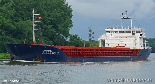
 DREMORA 2
Current Status
Where is the vessel?
DREMORA 2 is currently in 18 nm W of Maials, based on AIS data received about 1h ago.
Latest AIS update:
Current position: 41.36885° N, 29.91978° E (18 nm W of Maials)
Average speed (last 7 days): Loading…
Average speed (last 30 days): Loading…
Vessel profile: DREMORA 2 is a General Cargo Ship with dimensions m x m.
This page combines live AIS, route history, probable destination signals, nearby traffic, and port activity for practical vessel monitoring.
The current position of vessel DREMORA 2 is 41.36885 lat / 29.91978 lng. Updated: 2026-04-19 15:16:47 UTCNearest reference points:
- 19 nm NE of RUMELI FENERI
- Near Derince
- Near YARIMCA
Currently sailing under the flag of St.Kitts and Nevis ![]()
DREMORA 2 built in 2009 year
Deadweight:
5326 tDetails:
Live Vessel DREMORA 2 Analytics (details, animations, etc.)
Recent AIS points (UTC):
2026-04-19 13:37:46 UTC · 41.34583, 29.58492 · SOG 9.2 kn · COG 72°2026-04-19 14:22:05 UTC · 41.36243, 29.73538 · SOG 9.1 kn · COG 87°
2026-04-19 15:16:47 UTC · 41.36885, 29.91978 · SOG 9.2 kn · COG 88°
2026-04-19 15:16:47 UTC · 41.36885, 29.91978 · SOG 9.2 kn · COG 88°